Hire Developers With GIS Software Development Experience
We provide you skilled GIS back-end developers-for-hire to help you collect geospatial data and produce interactive GIS mapping solutions, from climate research facilities to urban planning development.

GIS Software Development
We effortlessly combine Geographic Information Systems (GIS) with powerful database capabilities and third-party GIS software setups, empowering businesses to create GIS maps and meet other geographic information demands.
GIS Programming Services
Our significant expertise in employing the best application development tools and programming languages, including C++, Visual Basic, Visual C#, Java, JSP, ASP, XML, GML, and Cold Fusion, contributes to our exceptional back-end GIS experience.
GIS Application Development
We develop unique GIS applications for tracking points or objects with precise projections and realistic scaling, then we gather geographic information from multiple sources and display it on a map for use in data analysis and insight.
GIS Database Design
We design and set up web service APIs (REST, SOAP, JSON, XML) to connect relational database management systems hosted in the cloud (Microsoft SQL Server, Oracle, MySQL, PostgreSQL) to GIS mapping tools.
Custom Geospatial Mapping Software
Our GIS mapping software specialists can modify any GIS program to offer constant access to geographical data in a dependable GIS app, providing shareable insights of crucial data to a variety of various sectors.
Geospatial Mapping Software
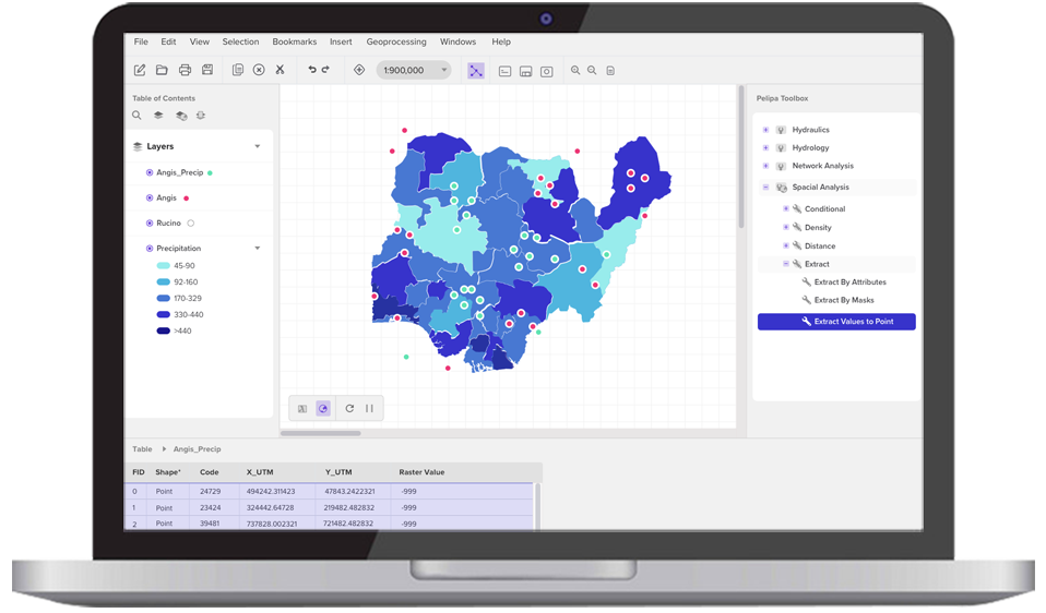
In order to develop sophisticated data modeling applications for topographical and hydrologic studies, precision farming, routing logistics, social science analysis, climate forecasting, and aerial drone mapping, we combine a variety of big data sources with spatial mapping technologies.
3D Visualization Software
To visualize any 2D and 3D thematic map, our 3D imaging/modeling expertise create overlays, quantitative and qualitative symbols, legends, annotation choices, transitions, and more by utilizing the power of ESRI's ArcGIS APIs and other rendering tools.
Geoprocessing & Geocoding
We provide automatic geoprocessing software that converts unstructured datasets (maps of addresses, businesses, landmarks, etc.) into meaningful inputs using open-source GIS platforms, such as Autodesk Civil 3D software (geo-coordinates).
Custom GIS Software Solutions
We will design & construct the ideal turnkey GIS software solution to satisfy business integration & workflow requirements, whether you need specific functionality or a distinct UI created especially to fit your business branding & technical needs.
Data Capture Solutions
We adapt and develop cutting-edge GIS mapping apps that let users submit geographic data that has been scanned, collected, transposed, and processed in real-time from satellite photos and aerial photography.
Data Management Solutions
To manage geographic geographical and non-spatial data grouped into tables, relationship classes, feature classes, topologies, and more, we'll add modules for data management and compilation to your existing GIS platform.
Image Management Solutions
We use Python scripts, the Mosaic Dataset Configuration Script (MDCS), and geoprocessing tools to automate your present image management workflow procedures for almost any sort of raster data. This approach is optimized for almost any type of imagery.
Hire Back-End GIS Specialists For Custom GIS App Development
The entire lifecycle of developing a GIS app, from conceptualization through requirements specification, design, programming, testing, and maintenance, is understood by our back-end GIS specialists.
In GIS programming languages including C++, Visual Basic, Visual C#, Java, JSP, ASP, XML, GML, and Cold Fusion, we have exceptional application development competence. Our GIS back-end programmers are skilled in:
- •ARCIMS® Internet map server
- •ERDAS® Image Processing Products
- •ESRI® ARC/INFO and AML
- •Microsoft® Visual Interdev
- •Tomcat/Apache
- •Other ESRI®/Suite of products & tools
- •ArcGIS Web Adaptor (IIS) enablement
- •Windows®/Unix/Linux
- •Python scripting
- •Cartography and map production
- •Advanced spatial analysis techniques
- •Expertise with mobile computing and its application to GIS